San Francisco, California / Parks and outdoors
Lands End Trail
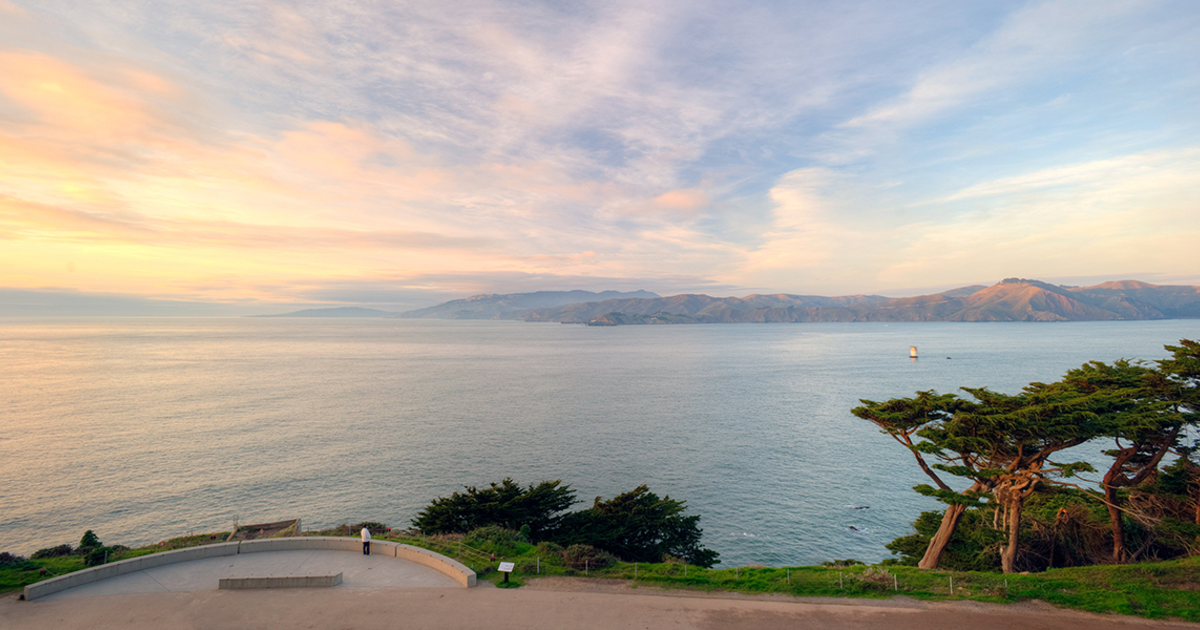
Explore San Francisco's northwestern corner on the Lands End Coastal Trail, where rugged cliffs, cypress forests, and the ruins of Sutro Baths meet stunning views of the Golden Gate Bridge.
What is the Lands End Trail known for?
It is known for scenic coastal hikes featuring views of the Golden Gate Bridge, rocky cliffs, and a woodsy forest of cypress and eucalyptus. Key highlights include the Sutro Baths ruins, Mile Rock Beach, and the Lands End Labyrinth.
What are the hours for the trails and visitor center?
The park trails are open 24 hours a day, 7 days a week. The Lands End Lookout visitor center is open daily from 9:00 a.m. to 5:00 p.m., except on holidays.
How long is the hike and how difficult is it?
The Coastal Trail is approximately 1.5 miles long and takes about an hour for a leisurely one-way walk. Alternatively, the area features a 5.5-km (3.4-mi) loop that is considered moderately challenging and takes an average of 1 hour and 33 minutes to complete.
What is the history of Lands End?
Historically, it served as a Native American (Ohlone) fishing ground, a treacherous coastline for ships, and the site of an amusement park and swimming facility.
What can I find at the visitor center?
The Lands End Lookout visitor center provides free trail maps, San Francisco mementos, and exhibits focused on natural and cultural history.
What should I check before going?
Use Gyde for context, then check official sources for current hours, tickets, construction, and closures.
What to know
Located at the northwestern corner of San Francisco, Lands End is a wild park within the larger Golden Gate National Recreation Area. The most-traveled path here is the Coastal Trail, a section of the California Coastal Trail that follows the historic railbed of the old Cliff House Railway. Visitors can experience a landscape that transitions from shady stands of eucalyptus and cypress trees to open, rocky cliffs overlooking the Pacific Ocean. The area possesses a deep history, having served as a Native American Ohlone fishing ground and a treacherous coastline for doomed ships. In more recent decades, it hosted an amusement park and a swimming facility. During a 20-year restoration project that began in 2006, the Parks Conservancy and National Park Service stabilized the sea-battered Sutro Bath ruins and preserved sensitive Ohlone shell middens. Modern visitors can start their journey at the Lands End Lookout visitor center, which opened on April 28, 2012. This facility provides free trail maps and exhibits on the natural and cultural history of the region. From here, hikers can descend wooden staircases to reach Mile Rock Beach and the Lands End Labyrinth. Depending on the route, visitors can take a leisurely 1.5-mile one-way walk or tackle a 5.5-kilometer loop. The loop is generally considered a moderately challenging route that takes an average of 1 hour and 33 minutes to complete, offering cliff-top views extending 30 miles along the California coast.
Visitor tips
- Visit the Lands End Lookout visitor center between 9:00 a.m. and 5:00 p.m. for free trail maps.
- Wear sturdy walking shoes, as the loop trail is moderately challenging and involves wooden staircases.
- Bring a windbreaker or jacket, as the trails are known to be wild and windy.
Nearby context
Situated at the westernmost point of San Francisco, Lands End provides a rugged natural escape from the city's urban core, blending wilderness with historical landmarks.
Sources
Evidence and links
-
Local Guide & AllTrails: Trail Length & Difficulty
The trail is about 1.5 miles long; a leisurely walk one-way takes about an hour.
inside-guide-to-san-francisco-tourism.com -
Modern Hiker: Scenic Features & Hike Stops
Lands End, the westernmost point in San Francisco, hosts one of the most scenic coastal hikes in San Francisco complete with views of the G…
modernhiker.com -
NPS and Parks Conservancy History & Restoration
At different times a Native American fishing ground, a treacherous coastline for doomed ships, and home to an amusement park and swimming f…
parksconservancy.org -
NPS: What Visitors See and Do
Lands End's trails winds their way around rocky cliffs above the ocean, moving through shady stands of cypress and eucalyptus and emerging…
nps.gov -
Wikipedia & Parks Conservancy Historical Features
Lands End is a park in San Francisco within the larger Golden Gate National Recreation Area. The most-traveled trail in Lands End is the Co…
en.wikipedia.org -
Wikipedia: Lands End Trail Identity
Lands End is a park in San Francisco within the larger Golden Gate National Recreation Area. The most-traveled trail in Lands End is the Co…
en.wikipedia.org